Loam
What a regional forecast can miss
Weather in town is a useful starting point. But a ride on a higher mountain or under heavy tree cover can have different conditions. We looked at how large those terrain differences are within six of Loam's riding regions.
This is a September 5, 2026 catalog snapshot. Each row includes all published networks grouped under that region on that date. Some groups extend well beyond the town in their name.
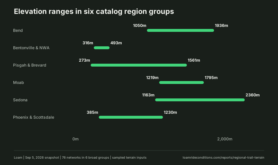
| Riding region | Networks | Elevation range | Elevation difference | Tree cover range |
|---|---|---|---|---|
| Bend | 8 | 1,050 to 1,936m | 886m | 0 to 56% |
| Bentonville & NWA | 18 | 316 to 493m | 177m | 10 to 92% |
| Pisgah & Brevard | 16 | 273 to 1,561m | 1,288m | 69 to 98% |
| Moab | 11 | 1,219 to 1,795m | 576m | 0 to 10% |
| Sedona | 11 | 1,163 to 2,360m | 1,197m | 0 to 44% |
| Phoenix & Scottsdale | 12 | 385 to 1,230m | 845m | 0 to 0% |
The mountain can need a separate check
Sedona's sample runs from 1,163m at Blowout Wash to 2,360m at Mingus Mountain, a difference of 1,197m. Mingus is a forested mountain above Jerome and Cottonwood, separate from the sandstone trails around Sedona.
The Pisgah & Brevard group spans 1,288m, from Saluda Confluence in South Carolina to Beech Mountain Bike Park in North Carolina. Those are separate destinations. The large range partly reflects the breadth of the regional grouping, rather than a single trail system with that much climbing.
Bend spans 886m, from Grey Butte / Skull Hollow to Newberry Crater. Phoenix & Scottsdale spans 845m, with Tortolita Mountain Park near Tucson at the high end. Check the mountain or outlying destination directly when planning a trip.
Tree cover varies for a different reason
Northwest Arkansas has the widest canopy range in these six groups: 10% at Runway Bike Park to 92% at Centennial Park. A paved bike park and wooded trail terrain are different surfaces as well as different levels of shade. The range does not tell us which one dries first.
Moab's sampled canopy ranges from 0% to 10%. All 12 Phoenix & Scottsdale entries have 0% in this snapshot. Where tree cover varies little, it offers little explanation for differences between networks; soil, drainage, and recent weather still matter.
A 0% or 100% reading describes the sampled terrain at a mapped location. It does not mean every section of a ride is exposed or shaded.
What to check before leaving
If your ride takes you away from town, compare the network's elevation and tree cover as well as recent rain and temperature. The region links in the table lead to current condition estimates for each network.
These terrain figures cannot tell you whether a trail is dry today. Check official access notices and give the trail more time if the surface is soft when you arrive.
Data and method
We selected six riding regions with detailed Loam pages and included every published network assigned to them in the snapshot. We took the lowest and highest elevation and canopy reading in each group. Each network contributes once, regardless of its trail mileage. All 76 entries had both measurements.
The source is Loam's published terrain catalog, using its existing region assignments. Elevation is in meters above sea level and canopy is percent tree cover. These are terrain estimates at mapped locations, not measurements along every trail. Overlapping network entries can describe some of the same ground.
This comparison contains no weather replay, rider observations, or measured drying times. It cannot rank destinations by rideable days or show that one trail recovers faster than another. Later catalog corrections may change the values shown on live network pages.
Download the 76-network CSV or the JSON snapshot with source provenance. See Loam's data sources for the terrain providers.
About Loam estimates
Loam estimates conditions from weather, soil, and terrain. It does not measure the trail surface directly or override an official closure. Read how the estimate works and see the published checks and their limits.