Find your trail in Loam and turn on alerts. Watch one network free. No account needed.
How conditions vary around Pisgah and Brevard
This page includes the forest near Brevard and several farther destinations: Cherokee, the High Country near Boone, and the Tennessee Tri-Cities. Check each area separately; weather in Brevard does not describe them all.
Across the 17 networks Loam tracks here, elevation spans 4,226 feet and canopy runs from 69 to 98 percent. These measurements describe representative network points, not the full elevation range of every trail. Compare the individual forecasts and check local reports before choosing a ride.
Elevation range896 to 5,122 ft
Canopy range69 to 98%
Most shadedBent Creek, 98%
Most exposedBeech Mountain Bike Park, 69%
Tracked networks17
Mountain biking around Pisgah & Brevard
The useful unit here is the riding zone. Each one has its own exposure, elevation, and weather response.
Pisgah Ranger District
Davidson River and the Pisgah Ranger District provide access to national forest trails near Brevard. The Pisgah National Forest and Pisgah Ranger District entries overlap. Pisgah Area SORBA maintains much of the trail system.
2,208 to 3,333 ft91 to 96% canopy
Trail examples: Black Mountain Trail, Farlow Gap, Avery Creek, Coon Tree Loop, Buckhorn Gap, Pink Beds Loop Trail. Examples, not a complete inventory.
DuPont State Recreational Forest has forested singletrack and exposed granite domes. Follow its wet-weather guidance: if you leave tire marks, the trail is too wet. Wet granite can be slippery.
2,599 ft91% canopy
Trail examples: Ridgeline Trail, Reasonover Creek Trail, Three Lakes Trail, High Falls Loop, Sheep Mountain Trail, Grassy Creek Trail.
Bent Creek Experimental Forest is a US Forest Service research forest near Asheville. Bikes must stay on signed, designated trails to protect research plots.
2,631 ft98% canopy
Trail examples: Spencer Gap, Three Humps, BAD Fork, Shut-In NRT, Trace Ridge.
Fire Mountain Trails is on the Eastern Band of Cherokee Indians' Qualla Boundary in Cherokee. It is well west of Brevard and needs its own weather check.
2,569 ft92% canopy
No named trail list yet in the dataset for this network.
Beech Mountain Bike Park and Rocky Knob are near Boone in the High Country. Beech Mountain is a lift-served resort; Rocky Knob is a free Watauga County park. Check seasonal access and mountain weather.
3,540 to 5,122 ft69 to 92% canopy
No named trail list yet in the dataset for these networks.
Steele Creek Park in Bristol, Tannery Knobs in Johnson City, and Warriors Path State Park near Kingsport are in Tennessee's Tri-Cities. Check their conditions separately from Brevard.
1,509 to 1,788 ft80 to 90% canopy
No named trail list yet in the dataset for these networks.
Planning patterns, not opening dates. Live conditions and official access decide the day.
Spring
Higher trails can hold snow and freeze overnight while lower trails are thawed. Check the recent rain and forecast for your destination.
Summer
Dense tree cover slows drying between afternoon storms. Wet granite at DuPont can be slippery.
Fall
Falling leaves reduce shade, but extended rain can keep trails wet. Check recent rainfall before heading out.
Winter
Lower trails may be clear while the High Country has snow and freeze-thaw conditions. Check each network's access notices.
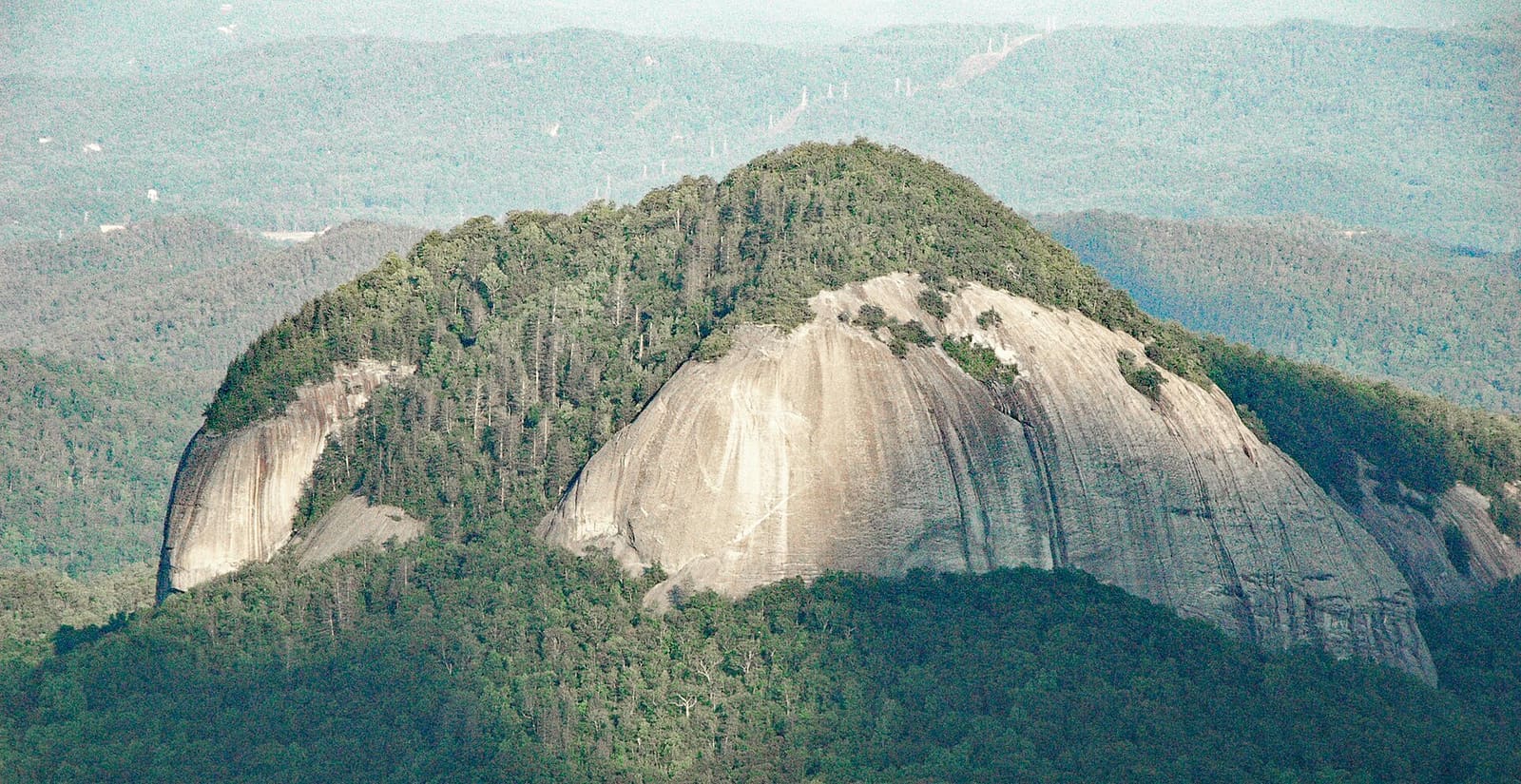
Looking Glass Rock, a granite dome inside the Pisgah Ranger District near Brevard, visible from many trails in that zone. Photo: James St. John, CC BY 2.0 · Cropped for display.
Check official closures
Check the US Forest Service for Pisgah, Big Ivy, and Bent Creek; the North Carolina Forest Service for DuPont; Brevard for Bracken Preserve; and the Eastern Band of Cherokee Indians for Fire Mountain. High Country parks have their own county or resort notices. Official closures take priority.
Are Pisgah & Brevard mountain bike trails rideable right now?
15 of 16 networks around Pisgah & Brevard currently have a PRIME or DUSTY verdict, meaning rideable conditions. For example, Beech Mountain Bike Park is PRIME and Boone/Rocky Knob Mountain Bike Park is CAUTION. Check the network page for details and closure notices.
Which Pisgah & Brevard trails are riding best today?
Rideable options around Pisgah & Brevard include Beech Mountain Bike Park (PRIME, firm, rideable conditions), Bent Creek (PRIME, firm, rideable conditions) and Berm Park (PRIME, firm, rideable conditions).
Where should I ride after it rains around Brevard?
Check recent rain and the current estimate for your chosen network. Heavy tree cover can slow drying. If the ground is still soft, give it more time.
Is DuPont's Ridgeline Trail rideable when it's wet?
Follow DuPont's wet-weather guidance: if you are leaving tire marks, it is too wet to ride. Check current forest notices and the condition estimate before heading to Ridgeline.
What season is best for mountain biking around Brevard?
Lower trails around Brevard can be rideable in many seasons, depending on rain and freezing. Higher destinations near Boone have more snow and a shorter season. Check the specific network and its access notices.
Is Black Mountain Trail rideable after it rains?
Check Davidson River or the Pisgah Ranger District page for a network estimate, then look for current Forest Service notices. These are not separate measurements of Black Mountain Trail.
Does rideable mean the trail is open?
No. Follow the land manager's posted closures even when Loam estimates rideable conditions.
Does this cover every mountain bike network near Brevard?
This page covers 17 networks, including riding near Brevard and farther destinations in Cherokee, the High Country, and Tennessee. It is not a complete list of trails near Brevard.
How often are Pisgah & Brevard trail conditions updated?
Loam updates condition estimates hourly. Each network page shows when its estimate was last updated.
What are these conditions based on?
Loam uses recent rain, soil, slope, slope direction, tree cover, and current weather to estimate how wet the ground is. These are estimates, not rider reports. Official closures take priority. See how the model works.
 Loam
Loam